ŽSR Public Interactive Map: A Modern Tool for Passengers and the Public
Railway Digitization Brings a New Level of Information
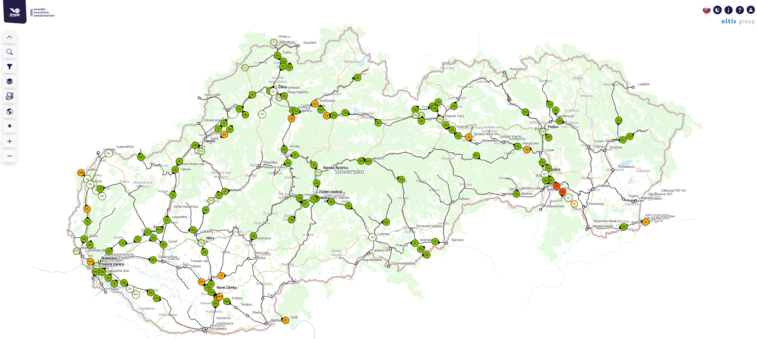
The Slovak Railways (ŽSR) is developing the ŽSR Public Interactive Map (VIM ŽSR) project, which aims to provide the public with a comprehensive and clear overview of the railway infrastructure, current train schedules, station facilities, and other important information. The goal of the project is to consolidate, in one place, data that passengers currently often have to search for across various systems.
OLTIS Group is participating in the project’s implementation, including the development of VIM ŽSR application, contributing through its many years of experience in information technology and solutions for transportation and logistics.
The new map will function as an interactive web portal with intuitive controls and thematic layers. Users will be able to select a specific area of interest and view information directly on the map of Slovakia.
Seven Thematic Layers in One Place
At the core of the solution will be a system of separate map layers:
- Train locations
- Information boards
- Railway stations and stops
- Accessibility for people with limited mobility
- Service suspensions and emergencies
- Construction and modernization
- Railroad crossings
Only one layer will be active at a time, ensuring maximum display clarity.
Users will also be able to choose between two types of base maps—a simple single-color map with the option to change the color scheme and a classic geographic map.
Train Locations Remain the Foundation of the System
The Train Locations layer will be based on the current solution available on the mapa.zsr.sk portal. The existing functions for displaying temporal and geographic locations of trains will be retained.
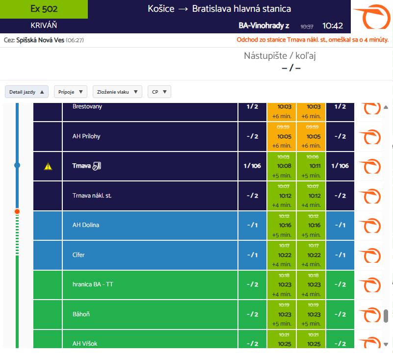
A new feature will be the expansion of detailed information about trains. For individual connections, the following will be displayed: train composition, information about car amenities, Wi-Fi availability, options for passengers with limited mobility, car class, areas for parents with children, and other services. This will give passengers a more detailed overview even before their trip begins.Information Boards Directly on the Map
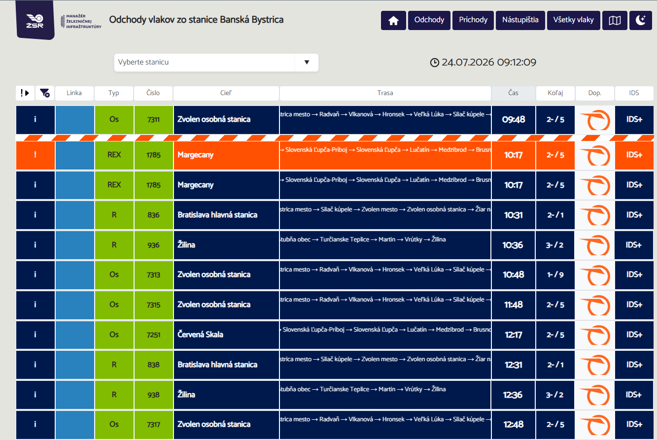
The Information Boards layer will allow users to track train departures and arrivals at transportation hubs displayed on the map.
Clicking on a specific station will display the current information board in a format adapted to the window size. A practical feature will be the ability to select a train directly from the board and immediately view its current location on the map.
Complete Overview of Stations and Stops
The “Railway Stations and Stops” layer provides detailed information about each transportation hub.
Selecting a station opens a page detailing information about the station, accessibility for people with limited mobility, and information boards. Thanks to this data, passengers will gain a comprehensive overview of the facilities at each station.
Focus on Accessibility
A key component of the project is the “Accessibility for People with Limited Mobility” layer, which is designed for people with limited mobility. Users will be able to filter stations based on the availability of platform lifts, assistance with boarding and alighting, and barrier-free access.
Detailed information will be displayed for individual transit hubs, including data on platforms offering lift facilities.
Current Service Disruptions and Traffic Restrictions
The “Service Disruptions and Emergencies” layer will provide information on both planned and ongoing restrictions to rail service. Users will get an overview of the scope of the closure, the start date, the planned end date, replacement bus service (NAD), and other operational restrictions.
Construction and Modernization
The new “Construction” layer will showcase major investments and modernization projects being carried out on the railway network. It will display section-by-section construction projects, station renovations, technological upgrades, and infrastructure development projects.
Upon clicking on a project, users will see details including the project name, implementation phase, start and completion dates, and a brief description of the project.
Another advantage will be the ease of data management via a web editor designed for authorized users.
Railroad crossings will remain part of the map
The “Railroad Crossings” layer will build on the features of the current ŽSR Infomap. The public will be able to search for railroad crossings by identification number, view the crossing’s location, use links to Google Maps, Street View, or other mapping services, and obtain basic information about the crossing.
Sensitive internal contact information will not be displayed in the public version.
One map, a wealth of information
The ŽSR Public Interactive Map project represents a significant step in the digitization of railway services in Slovakia. Passengers, people with disabilities, railway enthusiasts, and industry professionals will gain access to a centralized source of up-to-date and practical information.
OLTIS Group is helping VIM ŽSR fulfil its ambition to become a modern information portal that integrates operational data, infrastructure information, and passenger services into a single, clear, and user-friendly system.